
Last Mile Maps and Content
The Commonwealth’s Last Mile program is connecting unserved and underserved municipalities in Western and Central Massachusetts to 21st-century high-speed internet.
Testing Anchor to Open the Accordion
Testing 2nd anchor in accordion for expanding
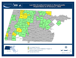
Of the 53 Last Mile communities, 40 towns have completed projects and an additional 10 municipalities have some premises lit but are not fully complete.
Click on a map image or title to open the full-size map. Free Adobe Reader software is required to open maps.
|
Last Mile Broadband Projects: Project Status, January 1, 2022 (310 KB) Map representing the status of last mile broadband projects. Towns in the MassBroadband123 service area that were considered "unserved" and "underserved" by broadband qualified for last mile broadband funding support from the Commonwealth. The map differentiates towns according to four categories: (1) towns with fully complete and operational networks, (2) towns with partially operational networks that are still in construction, (3) remaining last mile towns to be completed, and (4) previously served towns not included in the program. |
|
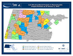
Last Mile Broadband Projects: Project Partners, January 1, 2022 (310 KB) Map of project partners and pathways chosen to construct broadband networks in last mile program towns. Towns in the MassBroadband123 service area that were considered "unserved" and "underserved" by broadband qualified for last mile broadband funding support from the Commonwealth. |